Image Details
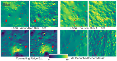
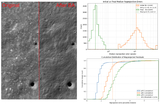
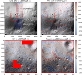
Caption: Figure 2.
Example close-ups of slope maps derived from LDEMs and SDEMs. Gaps between LOLA tracks are visible as smooth, interpolated terrain in the LDEM slope maps. Such gaps in LOLA coverage cause the LDEM to miss craters and features much larger than its 5 m pixel size and even its average effective resolution (see red arrows and circles). SfS leverages LROC NAC images to fill these regions with higher-resolution information.
Other Images in This Article
Show More
Copyright and Terms & Conditions
© 2026. The Author(s). Published by the American Astronomical Society.
Copyright ©
2026 Astronomy Image Explorer. All Rights Reserved.