Image Details
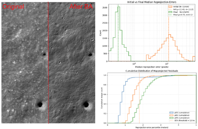
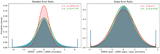
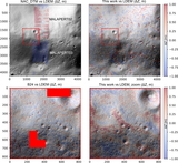
Caption: Figure 5.
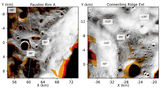
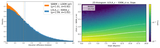
Left: 200 m × 500 m cutout of a maximum-illumination mosaic before and after bundle adjustment (BA) of the underlying 1 m pix−1 NAC images. The “After BA” portion shows clear terrain details hidden by aliasing in the “Original” half. Top right: pre- and post-BA median reprojection errors (in units of the native ∼1 m pixel resolution) for all NAC images across all regions. BA significantly reduces residuals from 11.41 ± 11.25 pix to 0.33 ± 0.12 pix. Bottom right: discrepancies in matched-point coordinates between map-projected images. While the 95th percentile (p95) of residuals for each image is below the target SfS resolution of 5 m pix−1, we remove all images with an 85th percentile (p85) >1.8 m from the final selection to ensure the highest-quality supporting dataset.
Other Images in This Article
Show More
Copyright and Terms & Conditions
© 2026. The Author(s). Published by the American Astronomical Society.