Image Details
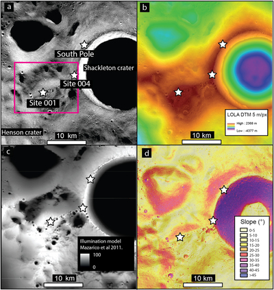
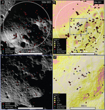
Caption: Figure 1.
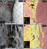
Context image showing location of the south pole and Shackleton crater; see Figure A1 for an outline of the region mapped here. White stars show the location of the south pole, site 001 (222.69°E, 89.45°S) and site 004 (204.27°E, 89.78°S). Pink square shows the location of the Artemis III candidate landing site, “Connecting Ridge”. (a)–(c) show the south pole and the points of interest of sites 001 and 004 in relation to Shackleton crater. (a) NAC mosaic (map assembled by Arizona State University and downloaded from Moon Trek (Day & Law 2018)) of the Shackleton region. (b) LOLA DEM (5 m pixel−1) overlaid on a hillshade made using the LOLA DEM, showing the elevation of the Shackleton crater and surrounding region. (c) WAC illumination mosaic LROC. (d) Slope map overlaid on hillshade, both made using the LOLA (5 m pixel−1) elevation data.
Other Images in This Article
Copyright and Terms & Conditions
© 2022. The Author(s). Published by the American Astronomical Society.