

Image Details
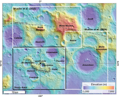
Caption: Figure 1.
Geographic setting of the lunar south pole with our study area (black box). The white boxes show the extents of the 1:100,000 scale geologic maps of Amundsen crater (L. Wueller et al. 2024) and the Mons Malapert–Mons Mouton region (L. Wueller et al. 2025). The dashed gray line indicates the position of the outer SPA rim (second fit of H. Bernhardt et al. 2025). Figure 1 is displayed on the 20 m pixel−1 LRO LDEM topographic base map (M. K. Barker et al. 2023).
Other Images in This Article
Copyright and Terms & Conditions
© 2026. The Author(s). Published by the American Astronomical Society.

Copyright ©
2026 Astronomy Image Explorer. All Rights Reserved.
