Image Details
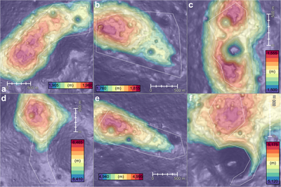
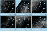
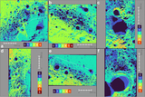
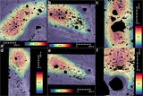
Caption: Figure 3.
Close-up views of the six target sites, represented by color-coded elevation of the 10 m pixel−1 SPLDEM2021 mosaic (M. K. Barker et al. 2023) combined with shaded relief. (a) CR1, (b) GR1, (c) GR2, (d) LP1, (e) MP1, (f) MP2. The relative height range of 55 m is divided into 11 5 m intervals. White polygons indicate areas we identify as suitable for future landing/roving. The shaded relief is visually enhanced with 10× vertical exaggeration and overhead illumination.
Other Images in This Article
Show More
Copyright and Terms & Conditions
© 2025. The Author(s). Published by the American Astronomical Society.
Copyright ©
2026 Astronomy Image Explorer. All Rights Reserved.