

Image Details
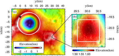
Caption: Figure 1.
DEM of the lunar south polar region in a polar stereographic projection. The south pole is marked by a black pentagram, and the Shackleton impact crater is outlined by a white circle. Panel (a) shows the regional DEM, with the Chang’E-7 landing area indicated by a black square. Panel (b) presents a high-resolution DEM of the landing area, where the white square delineates the inner domain used for illumination simulations and temperature studies. Elevations in both panels are given in kilometers. The horizontal and vertical axes correspond to the y- and x-axis direction of the south pole stereographic projection, respectively.
Other Images in This Article
Copyright and Terms & Conditions
© 2026. The Author(s). Published by the American Astronomical Society.

