

Image Details
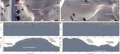
Caption: Figure 4.
GPR imaging and interpretation of the internal structure of Taklamakan dunes. (a), (b) UAV orthophotos corresponding to two representative 900 MHz GPR profiles. Red curves mark the GPR survey tracks, which traverse dune slopes, crests, and adjacent interdune areas. The yellow line marks the dune crest line. (c), (d) Processed GPR time sections corresponding to the survey lines shown in panels (a) and (b), respectively. (e), (f) Corresponding depth-converted and topographically corrected GPR sections using the effective relative dielectric permittivity of ﹩{\varepsilon }^{{\prime} }=3.27﹩. The blue curves indicate the surface topography. Three representative reflection geometries are directly marked in the corrected sections: shallow subhorizontal reflections, inclined reflection packages, and local arcuate reflections. The subhorizontal reflections are mainly observed in shallow parts of the profiles, whereas inclined reflection packages occur along dune slopes and within the dune body. Local arcuate reflections represent curved reflection geometries that are distinct from the surrounding subhorizontal or inclined packages. These geometries are interpreted as radar expressions consistent with preserved aeolian bedding, cross-strata and accretion surfaces, and locally developed bounding or reworking surfaces. The interpretations are based on the depth-converted and topographically corrected reflection geometry rather than on the apparent geometry in the uncorrected time sections.
Other Images in This Article
Copyright and Terms & Conditions
© 2026. The Author(s). Published by the American Astronomical Society.

