

Image Details
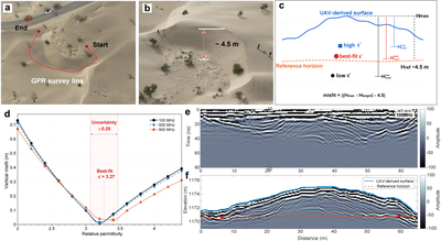
Caption: Figure 2.
Typical GPR survey geometry, dielectric-permittivity calibration, and topographic correction for a representative profile across Study dune 1, identified in Figure 1(d). (a) UAV image acquired directly above the dune, with the red curve showing the GPR survey line. (b) Oblique UAV image acquired from above the lee side of the dune, showing approximately 4.5 m of relief between the dune crest and the surrounding interdune area. The camera position for panel (b) is marked in Figure 1(c). (c) Schematic illustration of radar depth and elevation conversion using different relative dielectric permittivities, ﹩{\varepsilon }^{{\prime} }﹩. (d) Misfit between radar-derived and UAV-measured dune relief as a function of ﹩{\varepsilon }^{{\prime} }﹩. The integrated best-fit value is ﹩{\varepsilon }^{{\prime} }=3.27﹩, with an approximate sensitivity range of ±0.20 under an allowable vertical misfit of 0.1 m. (e) Processed GPR time section along the representative profile. (f) GPR section after depth conversion and topographic correction using the best-fit permittivity. The blue curve marks the surface elevation extracted from the UAV-derived DEM. The red dots indicate the flank reflection picks used for calibration, and the orange dashed line represents the basal reference constrained by these picks.
Other Images in This Article
Copyright and Terms & Conditions
© 2026. The Author(s). Published by the American Astronomical Society.

