

Image Details
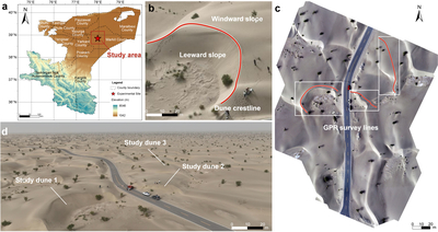
Caption: Figure 1.
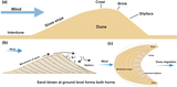
Study area, dune morphology, and GPR survey layout in the Taklamakan Desert. (a) Geographic location of the study area within the Taklamakan Desert. The base map shows regional topographic relief and the field survey location; the red marker indicates the GPR experimental site. (b) High-resolution UAV orthophoto of the representative dune, showing the dune crest line, stoss slope, and lee slope. (c) Orthophoto of the study area and layout of the GPR profiles. Red lines mark the GPR profiles, which cross dune slopes, crests, and interdune areas. (d) Oblique UAV image showing the investigated dunes and the surrounding aeolian geomorphic setting.
Other Images in This Article
Copyright and Terms & Conditions
© 2026. The Author(s). Published by the American Astronomical Society.

