

Image Details
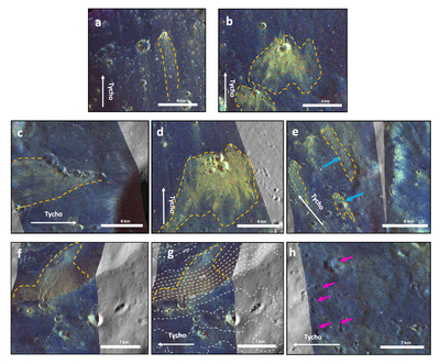
Caption: Figure 14.
Diversity of radar tails. (a) Isolated secondary crater with thin and long radar tail (79.922°S, 338.664°E). (b) Crater with a wide radar tail (59.07°S, 343.709°E). (c) Secondary craters forming a linear crater chain (42.829°S, 342.18°E). (d) Cluster of secondary craters (59.801°N, 344.08°E). (e) Craters with radar tails that overlap preexisting primary craters (pointed with blue arrows), suggesting a more ballistic-like emplacement (54.299°, 355.121°). (f) Craters with radar tails following the topography and deviating from the orientation of the ray, suggesting a flow-like emplacement (41.869°S, 0.339°E). (g) Same area as panel (f); here the dashed white contours are 500 m apart, representing topographic information from LOLA (M. Barker et al. 2016). (h) Secondary craters without radar tails (pointed by magenta arrows, 46.415°S, 356.223°E). Dashed orange lines represent the enclosed area of the radar tails; white arrows show the orientation of Tycho. The background dataset is the Wide Angle Camera images.
Other Images in This Article
Show More
Copyright and Terms & Conditions
© 2026. The Author(s). Published by the American Astronomical Society.

