Image Details

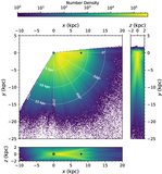
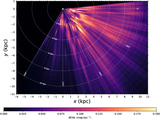
Caption: Figure 1.
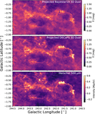
Schematic overview of the process of turning images of the sky into a 3D map of dust. The DECaPS2 survey forms the foundation of our 3D dust map, whose photometric colors are combined with complementary photometric (VVV, 2MASS, unWISE) and astrometric surveys (Gaia) where available and fed into our stellar inference framework. We use the brutus stellar inference framework to infer the distance, extinction, and stellar type of hundreds of millions of stars. We then group stars into pixels and fit the set of distance–reddening measurements along the line of sight in each pixel to generate a 3D map of dust.
Other Images in This Article
Show More
Copyright and Terms & Conditions
© 2025. The Author(s). Published by the American Astronomical Society.