Image Details
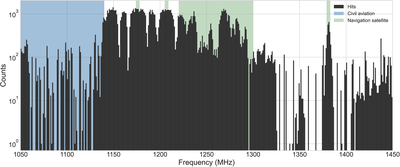
Caption: Figure 3.
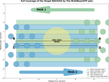
Distribution of signal hits detected across the five GCs. The hit density is extremely high in two primary regions. A saturated block of hits from 1220–1300 MHz corresponds to the navigation satellite band (green), rendering it unusable. A dense, but resolved, cluster of hits aligns with the civil aviation allocation (blue, 1030–1140 MHz). Notably, a strong, isolated hit peak at 1381.05 MHz is also explained by a navigation satellite downlink (GPS L3),
Other Images in This Article
Copyright and Terms & Conditions
© 2025. The Author(s). Published by the American Astronomical Society.
Copyright ©
2025 Astronomy Image Explorer. All Rights Reserved.