Image Details
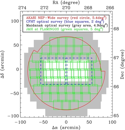
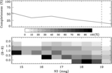
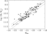
Caption: Figure 1.
Imaging coverage of the ANWS. The center coordinates of the ANWS are at (α = 18 h00 m00 s, δ = +66°36′00''). North is up and east is to the left. The AKARI IR (2–24 μm) data (5.4 deg 2), CFHT Megacam u* g′ r′ i′ z′ data (2 deg 2), Maidanak BRI data (4.9 deg 2), and KPNO JH data (5 deg 2) are represented by the red solid circle, blue dashed squares, the gray shaded region, and green squares, respectively.
Other Images in This Article
Show More
Copyright and Terms & Conditions
© 2012. The American Astronomical Society. All rights reserved.
Copyright ©
2025 Astronomy Image Explorer. All Rights Reserved.