Image Details

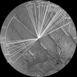
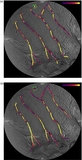
Caption: Figure 9.
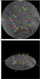
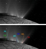
(a) Three VIMS hot spots and one cold “calibration” spot from the E11 Enceladus flyby (Blackburn et al. 2012), and another VIMS hot spot detected during the E18 flyby (Goguen et al. 2013), overlaid as crosses on a magnified portion of Baghdad Sulcus (Figure 3(a)). Translated into the Voyager system coordinates, the {lat, lon} coordinates in degrees are: for E11—lower {−83.00, 26.00}, middle {−84.30, 23.70}, upper {−85.20, 21.50}, and cold spot {−85.75, 24.98}; for E18—{−82.36, 24.74}. The inset shows the absolute 1σ uncertainties in the locations of the E11 VIMS sources (∼4 km) and those of the E18 spot (∼1.0 km). (Note that the coordinates of the E11 hot spots (shown in red) have been kindly re-computed from the original VIMS data by J. Goguen (2013, private communication); the coordinates of the cold spot (shown in white) are taken from Blackburn et al. 2012.) (b) Same as (a), except the VIMS E11 spots have been shifted in unison by {−20, 12} pixels, corresponding to ∼2.8 km, to coincide exactly with the jets' locations on the fracture; the E18 spot has been shifted by {−13, −3} pixels, or ∼1.6 km, also to coincide with the jet's position. These shifts are comparable to the 1σ uncertainties assigned to the VIMS measurements plus the positional errors in the underlying map of ∼0.6 km. To within all uncertainties, the lowest latitude E11 spot and the E18 spot are one and the same and coincide with (green) Jet #33.
Other Images in This Article
Show More
Copyright and Terms & Conditions
© 2014. The American Astronomical Society. All rights reserved.
Copyright ©
2024 Astronomy Image Explorer. All Rights Reserved.