Image Details
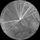
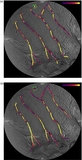
Caption: Figure 3.
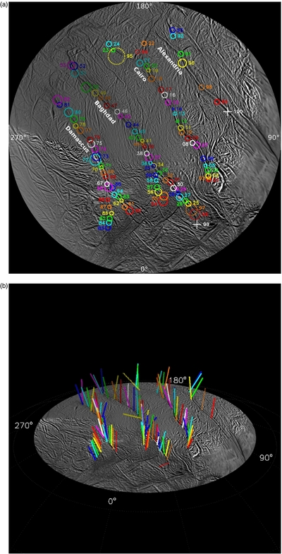
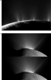
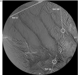
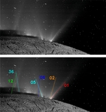
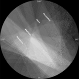
(a) Polar stereographic basemap of Enceladus' south polar terrain (SPT) on which has been plotted all 100 jets sourced in this work. The circles are the 2σ uncertainties; the associated numbers are the jet IDs used in this work. Five sources are indicated by dashed circles because each of these jets appeared in only one observation set; i.e., we are confident of their source locations, but their tilts remain indeterminate. Two crosses indicate two jets, each observed in one image only but each intersected by the shadow of Enceladus, allowing a determination of the fracture they lie on. (b) A 3D map of all 98 jets found in this work whose tilts have been determined. While some jets are strongly tilted, it is clear the jets on average lie in four distinct "planes" that are normal to the surface at their source location. Dotted vectors indicate jets whose sources were determined from images acquired in one observation set only and consequently have a large uncertainty on their tilt. (c) The ISS basemap on which has been plotted the four ground tracks derived from images within sets JJJ, XX, and U. The source locations indicated (Jet #99 in set JJJ) on Baghdad and (Jet #100 on set XX) on Alexandria are the only two determined by direct use of the height of Enceladus' shadow on the jet plus a single ground track. The Set U ground track is discussed in Section 6.
(A color version and animation of this figure are available in the online journal.)
Other Images in This Article
Show More
Copyright and Terms & Conditions
© 2014. The American Astronomical Society. All rights reserved.