

Image Details
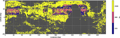
Caption: Figure 9.
Subsurface thermal inertia derived from Mars Global Surveyor TES data assuming a two-layer subsurface model. The map indicates the thermal inertia of the bottom layer of the two-layer models of N. E. Putzig & M. T. Mellon (2007). Dark gray indicates either regions above the 1 km elevation cutoff or where N. E. Putzig & M. T. Mellon (2007) did not identify a two-layer model that adequately fit the TES data.
Other Images in This Article




Show More
Copyright and Terms & Conditions
© 2026. The Author(s). Published by the American Astronomical Society.

Copyright ©
2026 Astronomy Image Explorer. All Rights Reserved.
