

Image Details
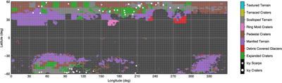
Caption: Figure 6.
Geomorphology map identifying regions with features relevant to subsurface ice. While a pixel may have more than one type of feature, only the most ice-constraining feature is shown (see Figure 5 and corresponding text). Dark gray regions have no relevant geomorphology or are above the 1 km elevation cutoff.
Other Images in This Article




Show More
Copyright and Terms & Conditions
© 2026. The Author(s). Published by the American Astronomical Society.

Copyright ©
2026 Astronomy Image Explorer. All Rights Reserved.
