Image Details
Caption: Figure 1.
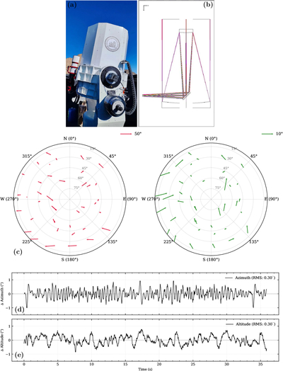
(a) The SYSU 80 cm infrared telescope at Lenghu on the Tibetan Plateau. (b) Optical path of the J-band system. (c) Pointing error maps across different azimuth and elevation angles. The left panel shows the uncorrected results (rms ∼ 22﹩\mathop{.}\limits^{\unicode{x02033}}﹩4), and the right panel shows the results after pointing model correction (rms ∼ 5﹩\mathop{.}\limits^{\unicode{x02033}}﹩7). (d) and (e) represent the telescope’s open-loop tracking accuracy in the azimuth and altitude directions, respectively.
Other Images in This Article
Copyright and Terms & Conditions
© 2026. The Author(s). Published by the American Astronomical Society.
Copyright ©
2026 Astronomy Image Explorer. All Rights Reserved.