Image Details
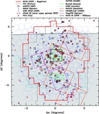
Caption: Figure 5.
Region surveyed by the NGVS overlaid on the Galactic extinction map from Schlegel et al. (1998). The gray scale corresponds
to
E(
B −
V) values, as shown in the legend at the bottom. The area in red shows the footprint of the NGVS, which covers an area of 104 deg
2, as well as four "background" fields (4 deg
2 in total) that are located three virial radii (≈16.5 deg) from the cluster center. The crosses indicate the location of M87
and M49, which mark the centers of Virgo's two main substructures. Blue and magenta lines show grids in ecliptic and Galactic
coordinates, respectively. The NGVS—the largest contiguous field mapped to this depth at optical wavelengths (
g = 25.9 mag, 10σ)—defines a low-extinction sight line at relatively high Galactic latitude (
![]() b
b
![]() ~ 74°) and low ecliptic latitude (
~ 74°) and low ecliptic latitude (
![]() β
β
![]() ~ 14°).
~ 14°).
Other Images in This Article


Show More
Copyright and Terms & Conditions
© 2012. The American Astronomical Society. All rights reserved.