Image Details
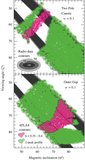
Caption: Figure 6.
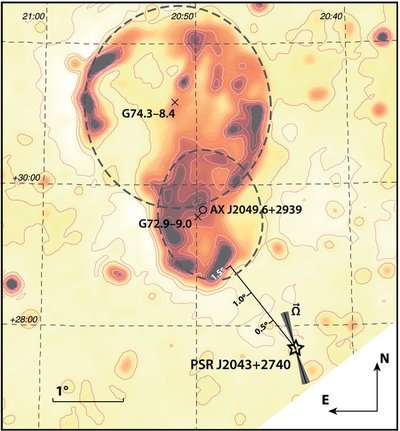
Radio map of the Cygnus Loop region from data from the Effelsberg 1.4 GHz Medium Galactic Latitude Survey (EMLS; Uyanıker et al. 1998,1999; Reich et al. 2004). In this map, the position of PSR J2043 + 2740 is shown with a star symbol. At the pulsar's position, we have also drawn the orientation of the pulsar's spin axis (solid, black line), as was derived from radio-polarization data (the shaded, gray area corresponds to the 1σ confidence level). In addition, the centers and extents of G74.3 − 8.4 and G72.9 − 9.0, as were calculated by Uyanıker et al. (2002), are shown with crosses and gray dashed lines, respectively. The position of the X-ray compact source, AX J2049.6 + 2939, discovered by Miyata et al. (1998) is marked with a circle. Lastly, the map also includes a scale showing the angular separation between the pulsar and the edge of the Cygnus Loop.
Other Images in This Article
Copyright and Terms & Conditions
© 2011. The American Astronomical Society. All rights reserved.