

Image Details
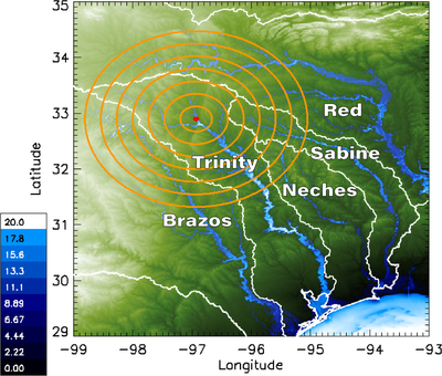
Caption: Figure 6.
Map view of simulated water depth up to 20 m, from deep blue (shallow) to white (deep), in the five studied river basins (Brazos, Neches, Red, Sabine, and Trinity). River-basin boundaries are shown in white and are derived from B. Lehner & G. Grill (2013). This is overlaying a green-and-white 30″ resolution digital elevation model (DEM) of eastern Texas. The impact location is shown as a red dot, and the hydrophobic radii from 25 to 175 km are shown in orange.
Other Images in This Article


Show More
Copyright and Terms & Conditions
© 2026. The Author(s). Published by the American Astronomical Society.

Copyright ©
2026 Astronomy Image Explorer. All Rights Reserved.
