

Image Details
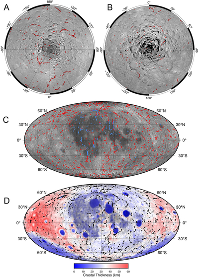
Caption: Figure 2.
Global map of lobate scarps. The locations of lobate scarps were digitized directly from map-projected, 2 m pixel-scale NAC images and mosaics and 100 m pixel-scale WAC monochrome mosaics. (A) North pole LROC WAC stereographic mosaic, with lobate scarps shown as red polylines. (B) South pole LROC WAC stereographic mosaic. (C) Global WAC mosaic, with Mollweide projection lobate scarps shown in red, SMRs shown in blue, and projection center longitude 0°. (D) GRAIL crustal thickness map (M. A. Wieczorek et al. 2013). The fault scarps are shown as black polylines. Mollweide projection centered at longitude 0°.
Other Images in This Article
Copyright and Terms & Conditions
© 2026. The Author(s). Published by the American Astronomical Society.

