

Image Details
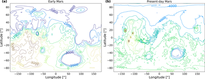
Caption: Figure A3.
Topography of (a) early and (b) present-day Mars. Contour labels represent elevation in meter with respect to the Martian areoid. The topography of early Mars before Tharsis formed (S. Bouley et al. 2016) was used for the global climate model simulation. The topography of present-day Mars is based on observations by MOLA on board Mars Global Surveyor (D. E. Smith et al. 1999)
Other Images in This Article
Copyright and Terms & Conditions
© 2026. The Author(s). Published by the American Astronomical Society.

Copyright ©
2026 Astronomy Image Explorer. All Rights Reserved.
