

Image Details
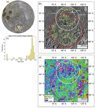
Caption: Figure 1.
Geological setting of the Australe region. (a) Eastern limb of the Moon. The black dashed line marks the 900E longitude. The orange polygons demarcate the mare boundaries, and the filled polygons correspond to the Australe region basalts (D. M. Nelson et al. 2014) covered in this study. (b) LROC Wide Angle Camera mosaic of the study area. The Mare Australe boundaries are marked in green, and the shaded regions correspond to the basalts with established emplacement ages as shown in (c) (H. Hiesinger et al. 2011; M. Martinot et al. 2018; N. Panwar & N. Srivastava 2024). (d) LOLA-derived elevation map of the Australe region. The white circles define the rings of the Australe North Basin (G. A. Neumann et al. 2015), and the red encloses the Mare Australe basalts in (b) and (d).
Other Images in This Article
Copyright and Terms & Conditions
© 2026. The Author(s). Published by the American Astronomical Society.

