Image Details
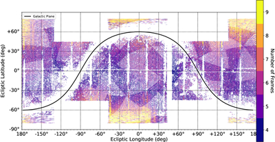
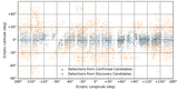
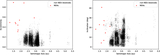
Caption: Figure 2.
Plot of the sky coverage of our collection of subfields searched by SALTAD. The x-axis is ecliptic longitude in degrees, whereas the y-axis is ecliptic latitude in degrees. The outline of each subfield is shown, where the color of the outline corresponds to the number of frames stacked to create the subfield. Regions within 10° of the ecliptic poles were excluded due to absence of main-belt objects expected in this region. Other gaps in coverage represent regions of the sky where there was an insufficient number of good overlapping frames to create a subfield or smaller gaps between adjacent subfields. Large gaps surround the galactic plane (solid black line) and regions of the sky in the WISE field of view during reaction wheel desaturation.
Other Images in This Article
Show More
Copyright and Terms & Conditions
© 2026. The Author(s). Published by the American Astronomical Society.