Image Details
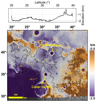
Caption: Figure 2.
Topographic map of Lacus Somniorum generated from SLDEM2015 data (File Name: sldem2015_512_30n_60n_000_045_float). The yellow dashed line indicates the elevation profile trajectory, with the profile undulations displayed above the main map. Black borders indicate the boundaries of lunar maria and plains units (C. Fortezzo et al. 2020), with yellow labels attached. Gray lines represent the mapped graben traces (C. Fortezzo et al. 2020).
Other Images in This Article
Copyright and Terms & Conditions
© 2026. The Author(s). Published by the American Astronomical Society.
Copyright ©
2026 Astronomy Image Explorer. All Rights Reserved.