

Image Details
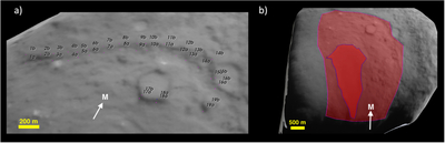
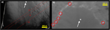
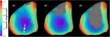
Caption: Figure 6.
Example of measurements of the cliff region and the smooth patch area using the SBMT software. (a) Pairs of points used to measure cliff elevations using the shape model. (b) Area measurements after projecting images onto the shape model. The smooth patch is indicated by the dark red region. The surrounding light red region delineates the cliff-bounded region. The cliff area for which we report area and mass corresponds to the light red region, excluding the dark red smooth patch. In both figures, the white arrows indicate the meridian (see Figure 2 for reference).
Other Images in This Article
Show More
Copyright and Terms & Conditions
© 2026. The Author(s). Published by the American Astronomical Society.

Copyright ©
2026 Astronomy Image Explorer. All Rights Reserved.
