Image Details
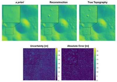
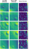
Caption: Figure 10.
A large area (19.2 × 19.2 km) is reconstructed using 37 rendered images (corresponding to a feasible set of illumination directions for a patch at 0°E, 40°N). The reconstructed topography recovers true features not present in the a priori topography, and the uncertainty map roughly tracks the true absolute error. The range of elevation in this region is >2 km.
Other Images in This Article
Show More
Copyright and Terms & Conditions
© 2026. The Author(s). Published by the American Astronomical Society.
Copyright ©
2026 Astronomy Image Explorer. All Rights Reserved.