Image Details
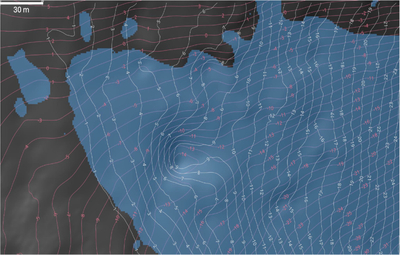
Caption: Figure 6.
Model of shadow amounts and heights as a function of location. This example of a shadow depth product is at a proposed location (30﹩\mathop{.}\limits^{\unicode{x000b0}}﹩9923 E, 85﹩\mathop{.}\limits^{\unicode{x000b0}}﹩4102 S) for entering permanent shadow during a reference VIPER traverse on 2024 November 16 at 18:00:00 UTC, partway through the prospecting activity. Blue is permanent shadow. The pink lines are surface elevation contour lines at 1 m spacing relative to the landing site elevation. The white lines are shadow depths at 1 m spacing (shadow depth is defined as the vertical distance from the local terrain to the Sun–shadow boundary). The outer shadow depth line is at 1 m (i.e., there is no 0 m line). The Sun is coming from the northwest at an azimuth of 319° with an elevation of 5°. The surface slope is 6﹩\mathop{.}\limits^{\unicode{x000b0}}﹩5 in the area of the traverse, hence the slowly increasing shadow depth. Note it is possible to have permanent shadow at the surface but have rover solar arrays and cameras in sunlight above the surface.
Other Images in This Article


Copyright and Terms & Conditions
© 2026. The Author(s). Published by the American Astronomical Society.