Image Details
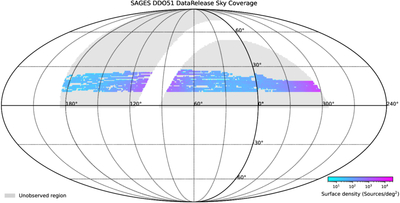
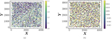
Caption: Figure 2.
Sky coverage of the SAGES DDO51 data released in this work. The gray region shows the full SAGES survey footprint, while the colored pixels mark the area included in this release, with color indicating the surface density of detected sources (sources per deg−2).
Other Images in This Article
Show More
Copyright and Terms & Conditions
© 2026. The Author(s). Published by the American Astronomical Society.
Copyright ©
2026 Astronomy Image Explorer. All Rights Reserved.