Image Details
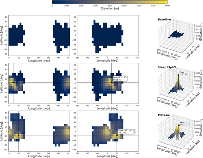
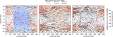
Caption: Figure 1.
Surface boundary configurations used in this study. Middle column: map view of continental distribution and topography with the substellar point centered at 0° longitude, or on the dayside. Left column: identical surface realizations centered on the nightside. Right column: corresponding three-dimensional renderings of the topography. Rows show (top) Baseline flat continent, (middle) Steep Uplift, and (bottom) Dayside Plateau. The mean elevation is comparable in the bottom two cases.
Other Images in This Article

Copyright and Terms & Conditions
© 2026. The Author(s). Published by the American Astronomical Society.
Copyright ©
2026 Astronomy Image Explorer. All Rights Reserved.