Image Details
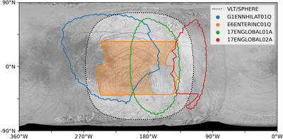
Caption: Figure 1.
Map of spatial coverage of the data sets used in this study. The black dotted line shows the useful spatial coverage of the VLT/SPHERE observation. The colored outlines show the total area observed in each NIMS data set (see Table 2). The shaded orange region shows the area of the “E6” observation where NIMS has full spectral coverage of the SPHERE wavelength range, which is used for full spectral modeling. Regions with extreme emission and incidence angles (>75°) have large residual photometric errors and so are not used in this study or shown on this map. The background visible-light reference image of Europa is from Becker (2013). 0° west is the sub-Jovian longitude, and 180° west is the anti-Jovian longitude.
Other Images in This Article


Show More
Copyright and Terms & Conditions
© 2022. The Author(s). Published by the American Astronomical Society.