Image Details
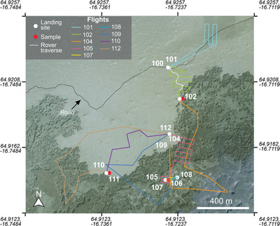
Caption: Figure 12.
Map showing the 2022 helicopter mission, including landing sites (white dots), sample localities (red dots), and flight paths (colored lines). Also shown for comparison is the 2022 rover traverse (white dashed line). The base map is sourced from Loftmyndir Einkahlutafélag. (50 cm pixel–1).
Other Images in This Article


Show More
Copyright and Terms & Conditions
© 2024. The Author(s). Published by the American Astronomical Society.
Copyright ©
2025 Astronomy Image Explorer. All Rights Reserved.