Image Details
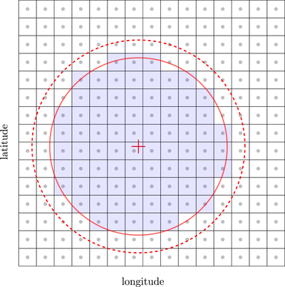
Caption: Figure 2.
Cartoon to illustrate the tessellation and the area calculation. The grid represents the tessellation of 0.°1-size bins along Galactic latitude and longitude, although in the actual grid the bin centers are not exactly aligned in longitude, because in order to keep the bin size constant, fewer bins are needed to cover a 360° parallel circle at high Galactic latitudes than at low latitudes. The red “plus” is the field center. The red dashed circle represents a GALEX field (≈1.°2 diameter) and the solid circle represents the 1° inner portion from which sources of GUVcat_AIS_050 are retained. The bins whose centers (dots) are inside the red solid circle are counted for the total area (shaded bins). Bins not entirely included in the circle are missed if the bin center is outside the circle, whereas the entire bin area is included if the bin center falls inside the circle. Statistically, the lack or excess of area from edge bins compensate each other. The error in the result is discussed in Section 4.
Other Images in This Article
Copyright and Terms & Conditions
© 2019. The American Astronomical Society.