

Image Details
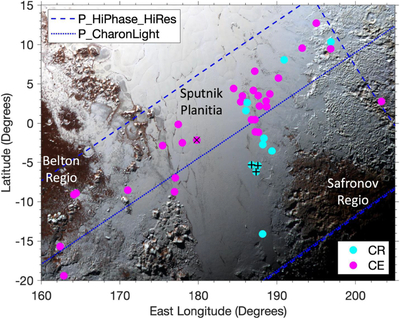
Caption: Figure 3.
Spatial distribution of CRs and CEs identified on Pluto. The background image is part of the best spatial resolution New Horizons MVIC false-color image of Pluto, which was acquired at a solar phase angle of 37°. Centroid locations of identified features are indicated by filled circles. The CRs and CEs vary in size and shape; some are larger than the filled circles, while others are not. CRs and CEs are not readily apparent in the background image; the primary purposes of this figure are the spatial distribution and geologic context. Numerous CRs and CEs are located in (i.e., on and/or above and/or within) volatile-ice-rich Sputnik Planitia and nearby regions with similar surfaces. Approximate boundaries of solar-illuminated areal coverage of each high solar phase angle image used to map the CRs and CEs are indicated by dashed or dotted lines. The approximately southwest–northeast alignment of CEs is likely a bias from the orientation of the high solar phase angle images used to map the CRs and CEs. CRs in Figure 1 are indicated by black plus signs, and the largest and easternmost CE in Figure 2 is indicated by a black cross.
Other Images in This Article
Copyright and Terms & Conditions
© 2025. The Author(s). Published by the American Astronomical Society.

