Image Details
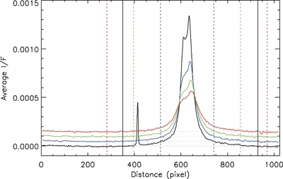
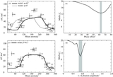
Caption: Figure 5.
Scans of vertically integrated and averaged I/F's for four non-overlapping horizontal integration regions, each 100 km tall, ranging from 100 km to 500 km altitude above the surface, obtained from a 4.46 km pixel−1 image (N1608976498). The boundaries of the 3, 2, and 1 km pixel−1 hypothetical images are marked by the red, green, and blue vertical dashed lines, respectively. The correspondingly colored dot-dashed lines connecting the vertical lines show where the backgrounds would be calculated for the hypothetical images. The black vertical lines denote the limits that were actually used to compute the 2D integrated I/F tabulated in Table 1.
Other Images in This Article
Copyright and Terms & Conditions
© 2014. The American Astronomical Society. All rights reserved.